")
")


Route description:
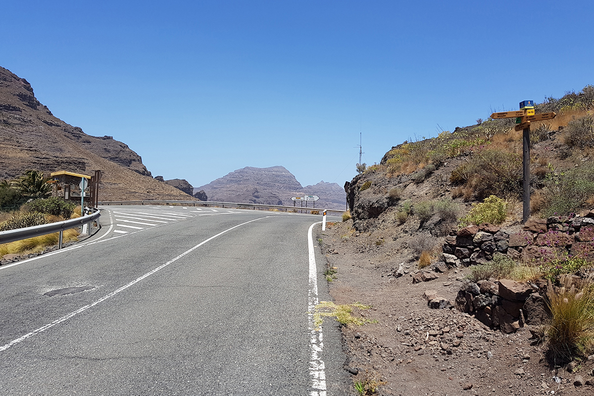
This route begins along the GC-200 main road from Mogán to La Aldea de San Nicolás, on the right hand side, just before the turning off to Tasartico. Taking the bus stop as a reference point, and opposite it, next to the main road, is a hiking signpost which should be accessed by crossing the road the furthest point possible from the bend so as ensure complete safety from oncoming vehicles.
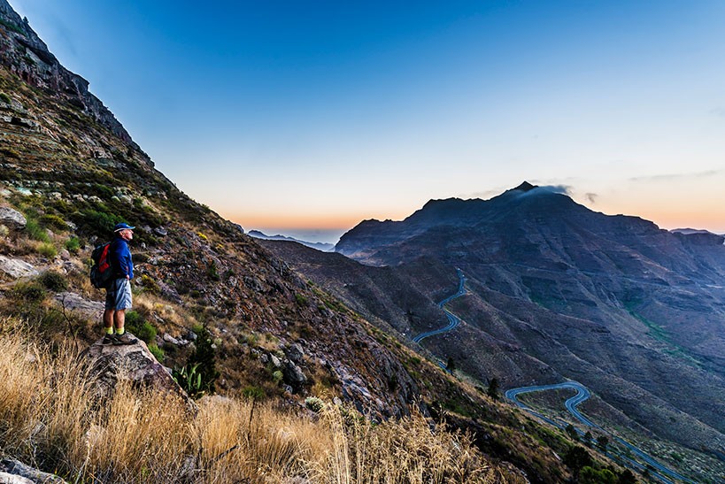
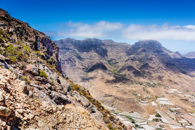
As you look ahead to where the route takes you, you may be mistaken for thinking that the “intermediate level” rating for the walk is wrong, as the near-vertical steepness of the surroundings is striking and it looks like you will have to walk along the edge of the cliff, but once you have started the walk, you will see that the path heads downwards along the less steep part of the mountain, at an area called El Anden Ancho or wide ledge.
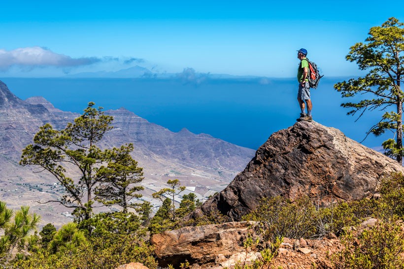
The greatest attraction of this route, apart from the enjoyment of walking along it, is reaching the plateau, a flat stone ridge called El Llano de Viso, which provides some stunning panoramic views. It is a great viewing point which can be reached by climbing up the ledges before descending back down the other side, past El Blanquizal and La Cueva del Mediodía, a geological landmark that is used as a sun dial.
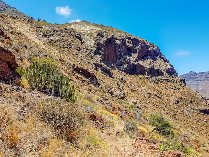
We start off in arid surroundings. There are a few pine trees dotted about at the top of the cliffs, a few examples located alongside the footpath and a few more just beyond La Peñonera. Further down the dirt track, there are some large pines that display the scars of the forest fire that swept through the area in 2010 and others, larger still, that look stumpy.
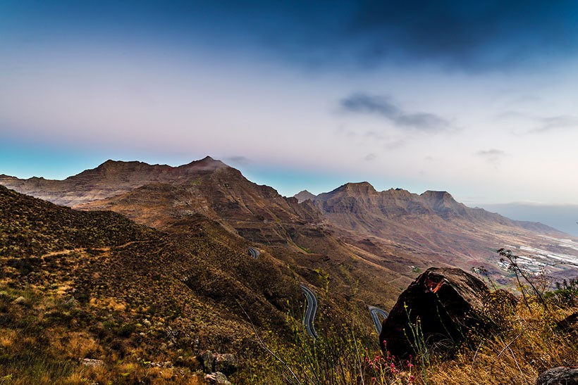
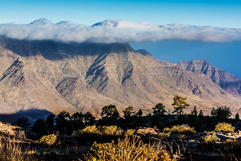
This route provides ample views, with clouds floating in on the trade winds that brush past the cliff tops of Guguy and Amurgar mountain, protected from the sun by a unique white blanket.
This landscape of pine woodland, mountains, sea of clouds, ocean and sky contrast with the other picturesque setting of Valle de la Aldea, where the seas are like glass sheets, similar to the glass in greenhouses, and the houses are dotted around in a haphazard fashion, breaking up the natural beauty of the valley.
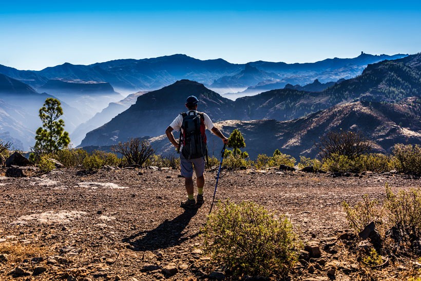
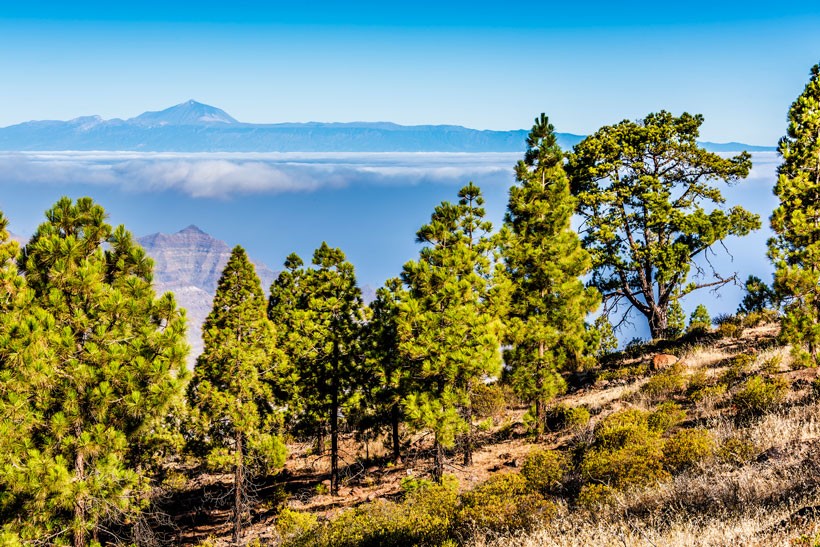
This route invites us to reflect for a moment, to consider our position as mortals up against the grand dimensions of the surrounding area, not only because of the imposing presence of the stunning Teide mountain from neighbouring Tenerife keeping us company along practically all our walk, also at some points we are wrapped up within the Guguy massif, the Roque Nublo and Bentayga rocks, the basins of Cuenca de Tejeda and Artenara... all of them the island’s own inspirational land and cliffs and seal of its identity.
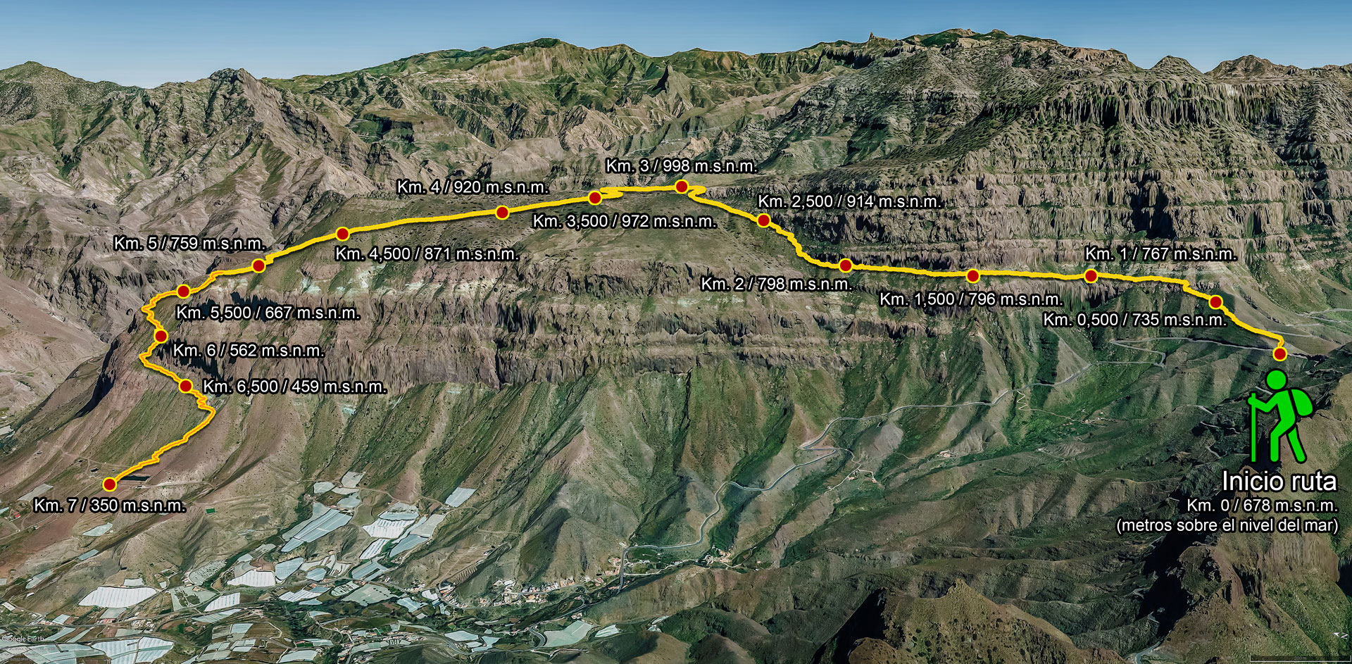
Section 1: El Andén
This first section is a gentle ascent of around 600 m, as far as a small, rocky wall which is easy to climb over, behind which takes us to the level of El Andén, or ledge, just below the cliff. This is known as el andén ancho, or wide ledge. From here we will be treated to some breath-taking views over the mountains of Los Horgazales, Los Pajaritos, Los Cedros, Andenes Negros, Lobas, La Aldea de San Nicolás, etc...
We continue along this stretch that meanders for a further 600 m or so until we reach an enormous pine tree on our right that is overhanging the steep slope, still bearing the scars of the huge forest fire from 2010. This pine tree is an ideal resting spot, to enable use to put our feet up for a while and enjoy the views as we build our strength back up.
As we leave this pine tree behind we move onto the narrow part of the ridge for about 700 metres and on a similar altitude to the previous section, with its little meanderings and the odd narrow stretch which is easily passable.
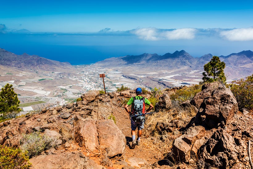
Opposite us now are views looking out over Llanos del Viso and its pine wood in the foreground, behind which the mountains of Amurgar and the peak of Los Verechuelos rise up over Valle de La Aldea, looking like they have been superimposed on the landscape, with the Atlantic Ocean dividing this setting from the northern stretch of the island of Tenerife.


Section 2: El Viso
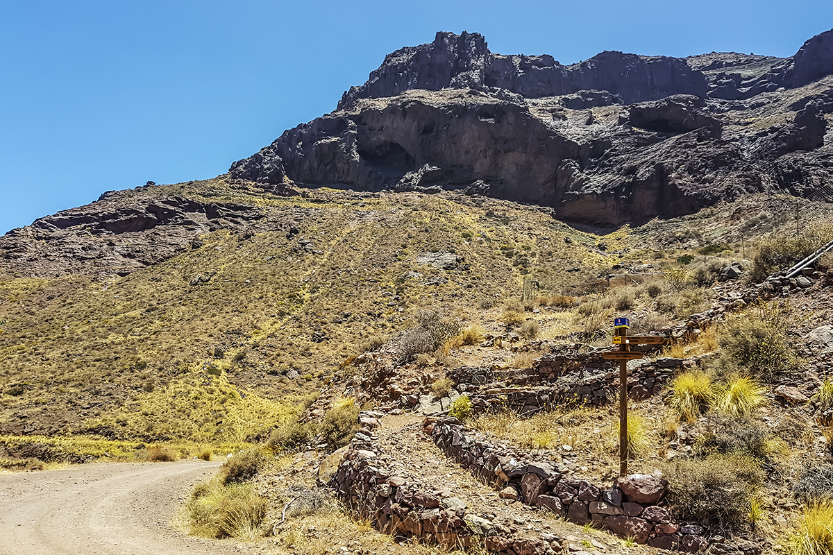
Once we have left El Andén behind, we face a demanding climb of around 850 metres, starting with short zigzags as far as some curiously-shaped boulders, the product of age-old rockfalls, La Peñonera. We are nearing the halfway point of the toughest part of this route, which situates us in the area around the extinct Cruz del Viso. To reach the cross and the signpost, we just need to negotiate a small rocky wall which is easy to climb over, paying attention to the stone boundary markers. Once over this wall, at the signpost, the path leads off to the right and joins a forest footpath with gives us two options: either a visit to Las Casas de Inagua, a round trip of around 4.3 km, or going as far as the house of El Pistolera, approximately 1.3 km there and back from the signpost.
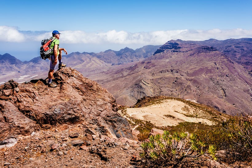
Avoiding these points, the footpath advances a further 250 metres or so virtually in a straight line northwest until it meets the forest footpath and continues for about 150 metres, to a point which it drops down to the left. Here we are given another recommendation: to continue straight ahead for about 300 metres as far as the highest point of Lomo del Viso, standing at 992 metres above sea level. Superb views are to be had from here, nearly 360 degrees towards Cuenca de Tejeda and notably the mountains of Los Hornos, Las Brujas, El Roque Nublo, El Roque Bentayga, Artenara, Montaña de Altavista and, opposite, from the bottom left and turn right, the mountains of El Lechugal, Los Cofres, Aslobas, the cliff tops of the stunning Guguy massif with the mountains of Los Horgazales, Los Pajaritos, Los Cedros, Amurgar, Valle de La Aldea and, in the background, beyond the sea, the imposing peak of the Teide.
It is an ideal spot for quiet contemplation, for a memorable snapshot and rebuilding our back for both body and soul.
600 metres away there is a white boundary marker or geodesic vertex situated at 995 metres above sea level, just three more than the highest point at Lomo del Viso, with the same views as before, but this time with the whole of Valle de La Aldea in the foreground. This added part to the walk, from the curve that descends down to El Blanquizal and as far as the geodesic vertex, adds only a further 1,850 metres to the route.


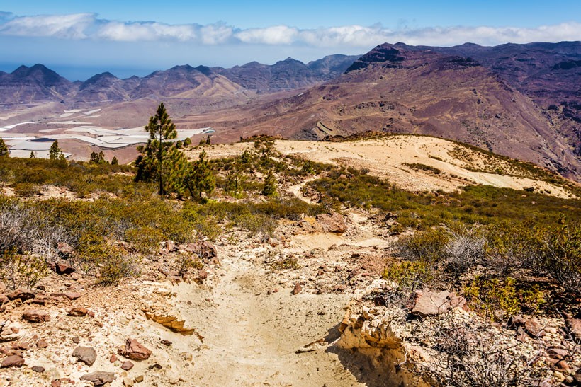
Section 3: El Blanquizal
This third section is a gentle and easy-going descent. Going back to the curve with the signpost, the descent begins down the forest track for around 1.1 km before continuing for about 400 metres along a footpath that leads to Blanquizal, leaving behind the last few pine trees and bits of shade that the route offers.
From this point there are plenty of fascinating images to be had of this great volcanic phenomenon, with areas of different shades and strange-looking boulders. On arriving at El Blanquizal, pay close attention to the boundary markers and follow them carefully down to the left, as this part of the route may lead to some uncertainty as to the course to follow.


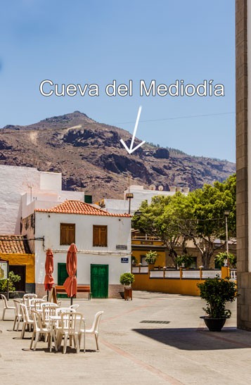
Section 4: Cueva del Mediodía
As we reach the lowest point of El Blanquizal at around 720 metres above sea level, we come to the final stage of the route, a clearly marked descent that runs for around two kilometres, an arid stretch with endemic tabaibas and cardones plants together with a number of almond trees along its banks.
Be careful here, as the loose ground, tiredness and over-confidence due to the satisfaction of reaching the finishing line may cause a slip-up.
The use of hiking sticks will be of great help at this point and will ensure there will be no mishaps. Having covered the first kilometre, we come to a ridge of around 200 metres in length just below La Cueva del Mediodía, which takes us immediately to El Lomo Arrastradero and the pond which catches the water from the Parralillo water channel, which signifies the optional end to our route.
At this point we have two further options that link up with the Mogán - La Aldea route. One of these is to continue to the left as far as La Degollada de Tasarte, making this route a circular one. The second option is to follow the Mogán – La Aldea route by going to to El Pinillo and ending up at calle Real de La Aldea in the town centre, where we can visit the ethnographic museums and stop and sample some local cuisine at its terrace bars.
We can also begin this route from calle Real towards Mogán town centre.


Documentary information of interest
Lomo del Viso
This is an area that rises up to 996 metres above sea level in the form of a plateau and constitutes the southern flank of Caldera de Tejeda and the eastern flank of Valle de La Ladera, the point at which the pine woodland begins. It is a rectangular beacon which provides stunning panoramic views both to the Guguy (Güi Güi) massif and to Roque Nublo, Roque Bentayga, Mesa de Acusa and generally over the whole Tejeda basin.
Cueva del Mediodía
At a time long ago when owning a clock was a luxury, locals resorted to sun-shade over natural elements such as stones, gorges, rocks, caves, crags and even pine trees as reliable references to be able to calculate 12.00 midday, (also known in religious circles as Hora del Angelus), and as sundials and hour markers.
Midday represented the time for farm workers to take a break and have a meal during their tough morning’s work. The shade also signalled the time for watering the crops.
In La Aldea, this sundial was represented by Cueva del Mediodía, meaning literally midday cave, when the sun shone directly over the shadow of the cave’s threshold, signalling the midday sun.
Blanquizal
These curious geological shapes of pale yellow-coloured tuff rock were formed during the final phase of the First Cycle of Gran Canaria (-15 to – 10 million years). The colour of these tuff rocks is due to the hydrothermal alteration which produced the volatile discharge of rocks that spewed out of fractures in the ground.
Geology
This visitor area stands over the oldest geological formations on the island, corresponding to Cycle 1, when huge amounts of basalt, trachyte and phonolitic lava was emitted. The subsequent long period of eruptive calm allowed erosion to once again shape the rocky relief and give it its current physiognomy.
Vegetation
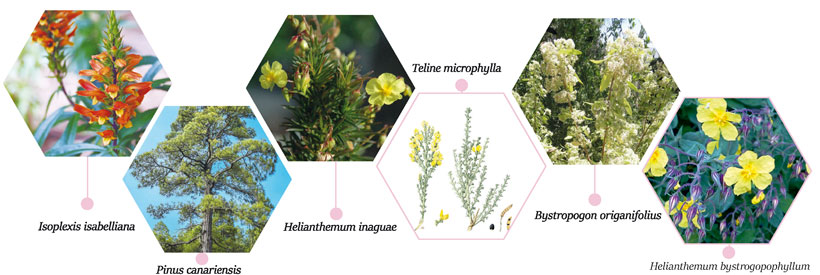
The pine forests that abound at this location in Inagua, together with those at Ojeda and Pajonales, constitute a largest continual forest mass on the island, and can be considered the most representative dry pine forests in Gran Canaria, thanks to high levels of preservation and large expanse. In general terms, it is a sparse woodland, due to the competition the trees face in order to create their own space on low humidity terrain, on elevated slopes and on little soil. The pine forests have adapted to drought and sunny conditions, a characteristic of this part of the island, and as such have a key role in the generating of underground moisture thanks to their ability to capture droplets of water from clouds through condensation (known as horizontal rain). In addition, they help maintain the little soil there is.
Depending on the altitude, gradient and the direction the hillsides are facing (which fundamentally determines the humidity, temperature and number of sunshine hours) the undergrowth, associated to the pine forest, varies substantially in terms of the presence and the density of different species.
Many different endemic species find refuge at scarps and cliffs containing little soil, including jarilla peluda bushes, jarilla de Inagua, gildana, cardoncillo (Ceropegia fusca), el pastel de risco (Greenovia aurea), magarza (Angyranthemum adauctum), as well as a diverse range of tree houseleek flowers (Aeoníum manriqueorum, A. percaneumyA.símsii).
To the west from El Blanquizal to Lomo Arrastradero, there are lower altitude plant species such as verode (Klenia neriifolia, part of the daisy family), tabaiba amarga shrubs (Euphorbia regisjubae), together with taginaste negro (Echium onosmifolium), hierba de risco (Lavandula minutolii) and cardons (Euphorbia canariensis) among others.
Fauna
This area is noted for its common buzzard (buteo buteo insularum) and Canary kestrel (Falco tinnunculus canariensis), as its most common birds of prey. Other species of birds of prey include the sparrowhawk (Accipiter nisus grantii) and the acrobatic Barbary falcon (Falco pelegrinoides).
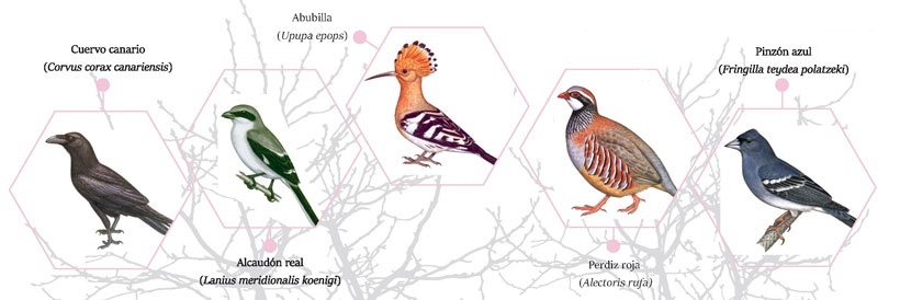
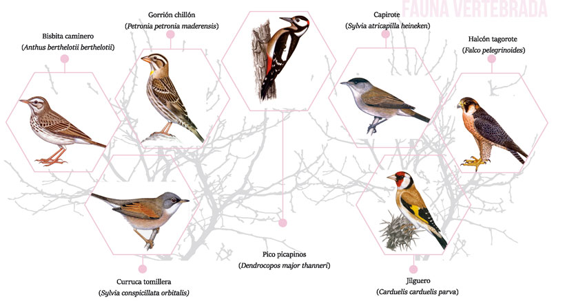
Other birds commonly found on the island include the Canary crow (Corvus corax canariensis), pipit (Anthus berthelotii berthelotii), canary (Serinus canarius), chickadee (Parus tenerijfae hedwigii), robin (Erithacus rubecula superbus), goldfinch or pinto (Carduelis carduelis parva), common greenfinch (Carduelis chloris aurantiiventris), Canary blackbird (Turdus merula cabrerae), rock sparrow (Petronia petronia maderensis), Canary Islands chiffchaff (Phylloscophus canariensis canariensis), blackcap or capirote (Sylvia atricapilla heineken), spectacled warbler (Sylvia conspicillata orbitalis), Sardinian warbler (Sylvia melanocephala leucogastra), hoopoe (Upupa epops) and blue chaffinch (Fringilla teydea polatzeki).
Reptiles are represented by three Gran Canarian endemic species that appear in the Canary Catalogue of Protected Species, namely the Gran Canaria giant lizard (Gallotia stehlini), the Gran Canaria flathead grey mullet (Chalcides sexlineatus sexlineatus) and the Boettger’s Perennial (Tarentola boettgeri). Amphibians are represented by the common frog (Pelophylax perezii), a species that abounds on the island.
Mammals to be commonly found include the Kuhl’s pipistrelle bat (Pipistrellus kuhli), free tailed bat (Tadarida teniotis) and mountain bat (Hypsugo savii).
Molluscs are represented by two species, namely Napaeus validoi (Enidae) and Plutonia nogalesi (Vitrinidae).
Anthropods are divided into two main groups: arachnids and insects.
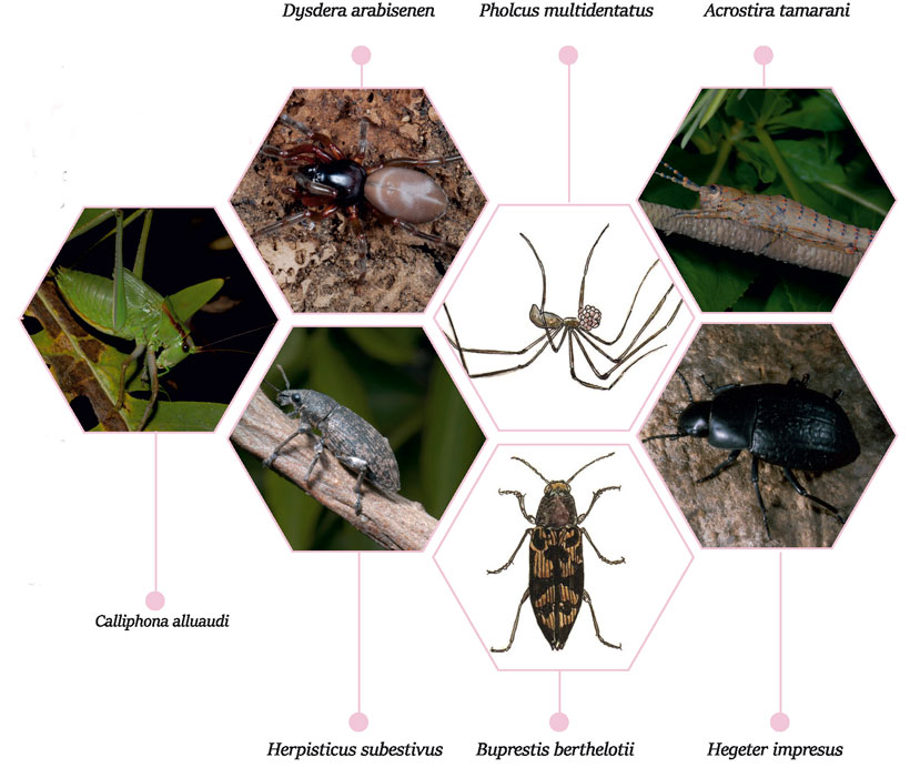
Arachnids are represented by several endemic species that are exclusive to Gran Canaria and a further two that are shared with neighbouring island Tenerife. The former include the dysdera (Dysdera arabisenen), the Bandama dysdera (Dysdera bandamae), Dysdera paucispinosa, the Los Tilos dysdera (D. tilosensis), Mesiotelus grancanariensis, the Gran Canaria wolf spider (Alopecosa grancanariensis), the long-legged spider (Pholcus multidentatus) and Spermophorides flava. The two species shared with Tenerife are the Dysdera iguanensis and the dysdera isleña (Dysdera insulana).
Diplopoda present two exclusive species, the Gran Canaria centipede (Dolichoiulus alluaudi) and the millipede (Dolichoiulus architheca).
There are also plenty of insects here at this natural space, the most common of which are beetles, with no fewer than 14 local endemic species, and a further two shared with Tenerife. There are taxonomic families (carabids, tenebrionidae or darkling beetles, buprestidae or jewel beetles, curculionidae or true weevils, etc.). Gran Canarian endemic species include the Calato de Gran Canaria (Cahthus angularis), Cymindis cincta, Gomerina de Gran Canaria (Gomerina nitidicolis), Olisthopus glabratus tamaranus, Cabezón de Gran Canaria (Nesacinopus fortunatus), Dibolia magnifica, the pine weevil (Brachyderes rugatus calvus), the Gran Canarian lazy weevil (Herpisticus subvestitus), plus Aplocnemus grancanariensis, Stictonectes canariensis, Linmebius canariensis, Hegeter impressus, Melansis kaszabi and Nesotes quadratus. Endemic to the Canaries are the pine beetle (Buprestis bertheloti) and the tiny Cucarro boliche enano (Arthmdeis curtus).
Other representative invertebrate species from other orders include: diptera, hymenoptera, lepidoptera and orthophera, comprising exclusive endemic species, both local and to the islands in general.
Diptera are a local endemic species, the Gran Canaria bee-fly (Exhyahnthrax canarionae) and Canariellum brunnipenne, which is shared with Tenerife.
Hymenoptera come in the shape of three local endemic species, namely Alastorynerus rubesoens, andrena (Andrena chalcogastra extrema) and Andrena vulcana ferina.
Lepidoptera include the species Eudonia parviangusta.
Finally, orthophera are also local endemic species, namely the Gran Canaria cigarrón de palo cicada (Acrostira tamarani), and the arminda grasshopper (Arminda brunneri), shared with Tenerife.
Bibliography and Photos; C – 1 Inagua Integral Natural Reserve.
IMPORTANT:
The information contained in these routes is for guidance purposes, which exclusively seeks to encourage sporting activity in natural surroundings and educational country walks. The Town Hall of La Aldea de San Nicolás provides this information for the benefit of users of this website, and waives any responsibility as to the current state of the routes, offer, quality and ownership of the areas that walkers pass through, etc.
Likewise, the Town Hall is not responsible for any errors, omissions, or for a user of this website going off course and suffering an accident. Hikers are reminded that they access these mountainous areas voluntarily and with informed consent, that is, each person should be responsible for their actions.